The 1000th anniversary of the Battle of Carham was commemorated in 2018, but the Carham story really begins another 1000 years or so before that when the Romans invaded these islands. The Roman occupation of Britain lasted approximately four hundred years, the southern part of the British Isles being far more ‘Romanised' but Roman influence covered virtually all parts of Britain and was certainly not limited by Hadrian’s Wall.
The north was more subject to military occupation rather than assimilation of the populations. Neither the Antonine nor Hadrian's Wall, whatever their purpose, formed a formal border. The original Celtic peoples were pushed westwards into what is now Cornwall, Wales, Cumbria and Strathclyde.

Four centuries after the conquest of Britain the Roman Empire was in decline and, after suffering repeated attacks from the Picts, Scoti, and Saxons, the occupation of these islands was no longer militarily, or economically viable and in around 430A.D. the Romans left the British Isles.
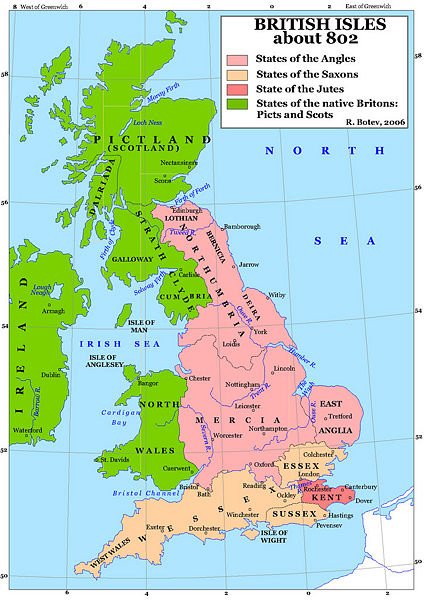
This left a power vacuum and the rich, fertile land of the British Isles became an irresistible target for the Germanic peoples of the Angles, Saxons and Jutes and with couple of centuries several distinct kingdoms had materialised. The rulers of these individual nations although known as “Kings” were in effect more local warlords. By the seventh century the largest, most advanced and most prosperous of these kingdoms was that of Northumbria which at its height reached from the River Humber to the Firth of Forth and from the East to West Coast

In the far north of what is now England the two Anglian kingdoms of Bernicia and Deira united to form Northumbria which prospered and became the largest and most developed nation in these islands by around 800AD Northumbria was renowned for military might and the kingdom stretched for the Humber to the Firth of Forth, and from the North Sea across to the Irish Sea in what is now Lancashire. Northumbria led the way and her people benefitted from military prowess, and artistic and religious progress.
Then Britain suffered, first from piratical Viking raids and later full scale Viking invasion. Lindisfarne was first attacked in 793AD.
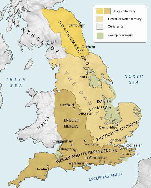
The Danes took control of a great swathe of the middle and south of the mainland, known as the Danelaw. Inevitably Northumbria came under threat and this once all-powerful kingdom contracted, being squeezed along all three landward sides by the Danes from the south, the Scots from the north and the Strathclyde / Cumbrians from the west. Northumbria became much reduced in size and lost much of its prestige and military power.

The times of 1000 years ago are often referred to as the Dark Ages. This is nothing to do with the quality of daylight, but rather because of the scarcity of written material and evidence which makes this period mysterious and events difficult to quantify.
Today we are used to seeing distinct boundaries and borders depicted on maps. Borders as such were not so defined a millennium ago, but kings, earls, landowners held sway within spheres of influence, and these could often be flexible to suit the prevailing conditions of the time.
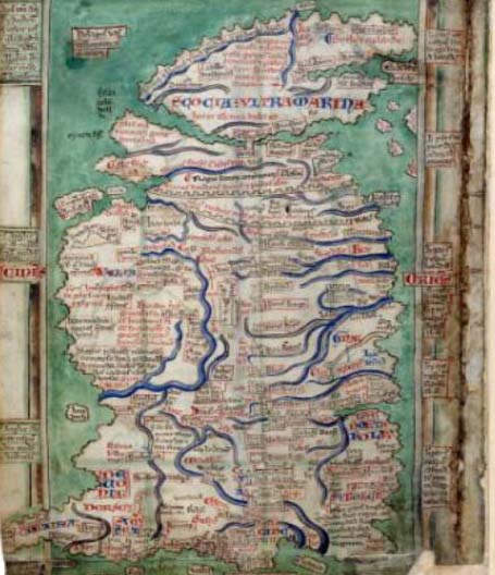
Perception of the shape of these islands land was very different to today, as can be seen on the Matthew Paris map of the British Isles drawn in 1250.

The Matthew Paris was a monk based in St. Albans and his map of 1250 showing a very strangely shaped Scotland which appears to be very nearly an island, only joined to mainland Britain at Stirling Bridge. This rather odd perception of the North is an indication that this area was considered by the ruling elite to be of minimal importance (a situation that continues to this day!!)
In around 900 AD, Wessex became the predominant military force and joined with Mercia to defeat the Danes and drive them out of England. Wessex, Mercia and Northumbria merged to become the country that today we recognise as England.
At this time Northumbria still extended as far north as the Firth of Forth but was under continual pressure from the Scots.
In 973AD, at a gathering in Chester, Lothian was ceded by King Edgar King of England to Kenneth King of Scots, but there is opinion that Kenneth was forced to do homage to Edgar.
This could have been a ploy to give the Scots access to Lothian on a non-permanent basis with final control remaining with the English king.
In 1005, after several rapid and short lived successions Malcolm II acceded to the throne as King of Scots, and in order to gain political advantage at home, raided southwards into Northumbrian territory and laid siege to the city of Durham.

Uhtred, an accomplished warrior, son of the Earl of Northumbria based at Bamburgh, gathered an army, raised the siege and drove the invader out of Durham. Malcolm II.was lucky to escape with his life, and retreated homewards to the highlands of Scotland.
Uhtred was made the Earl of Northumberland, even though the original Earl, his father, still lived. Uhtred's reputation as a mighty warrior was sealed. In 1016 after a previous failed attempted invasion the Danes reappeared and Cnut became King, thus ending the royal rule of the House of Wessex, Cnut also dispensed with the Anglo-Saxon earls and replaced them with choices of his own.
According to the writings of Simeon of Durham, Uhtred was ambushed and killed on the direct orders of Cnut this very same year of 1016. Uhtred was replaced as Earl of all Northumbria by Cnut’s man, Eric of Norway.
The change of the ruling elite caused confusion and realignment of allegiances in England, a situation now often overlooked because of the later and more famous and far reaching invasion of William the Conqueror in 1066.
After his defeat at Durham Malcolm II was not idle and, taking advantage of the turmoil in England caused by Cnut’s invasion and the termination of the rule of the royal House of Wessex, the King of Scots arranged a military alliance with Owen the Bald, King of Strathclyde.
At this time the Kingdom of Strathclyde included Cumbrian territory as far south as Penrith. Strathclyde / Cumbria was a distinct cultural area speaking a language often referred to as Strathclyde Welsh, a Celtic language related to that of Cornwall, Wales and the language of the Highlands.
The population on the eastern side from East Anglia as far north as the Forth of Forth were descended from the Angles thus in the northern part of Northumbria there was an East West cultural divide which was more distinct than the cultural divide North and South of the River Tweed
The Earldom of Northumbria becomes somewhat convoluted at this time. Eric of Norway has been declared Earl of all of Northumbria, but Uhtred’s family appear to claim the title of Earl of Bamburgh. Who held this Earldom at this point is a matter of controversy. The warrior Uhtred is the popular choice, but if, as Simeon of Durham claims, he had been killed in 1016 this is extremely unlikely.
The other candidate for the title is Uhtred's ineffectual brother, Eadwulf Cudel; Cudel being a reference to cuttlefish a soubriquet for coward.
In the summer of 1018 the armies of Malcolm II and Owen the Bald mustered at Caddonfoot near Galashiels, and marched eastward to be met by a hastily gathered force of Northumbrians, a force, according to Simeon, gathered from Tees to Tweed. The scene was now set for battle.
A 30 minute documentery film, 'Carham 1018 - The Start of the Border Story' is now available to view on The Battlefields Trust YouTube channel.
A shorter 7 minute documentery film, focusing on archeology at Carham has been produced, and is now available to view on The Battlefields Trust YouTube channel.
Please consider making a donation to Battlefields Trust North East to allow us to continue our work on the Carham 1018 Project.